When you click on links to various merchants on this site and make a purchase, this can result in this site earning a commission. Affiliate programs and affiliations include, but are not limited to, the eBay Partner Network.
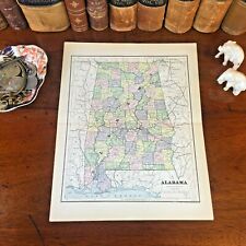
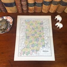
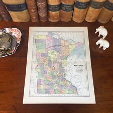
Original Antique 142-year-old Map of Dakota Drawn and Engraved for the 1882 Edition of The People's Cyclopedia of Universal Knowledge: A Compendium of Appendixes Invaluable for Reference in All Departments the Arts and Life, the Whole Brought Down to the Year 1882, with Pronunciation Conformed to Webster's Unabridged Dictionary, Illustrated with Over Five Thousand Engravings and Over One Hundred Color Maps of Each State and Territory of the United States, including City Maps, Continents, the World, and Every Country Across the Globe. Great for American History and Family Genealogy. Imaginative and Creative Gift. Fine Map for the Collector or Historian. Easily Framed. Original Map Drawn and Engraved by E.F. Fisk for the 1882 Edition of The People's Cyclopedia of Universal Knowledge: A Compendium of Appendixes Invaluable for Reference in All Departments the Arts and Life, the Whole Brought Down to the Year 1882, with Pronunciation Conformed to Webster's Unabridged Dictionary, Illustrated with Over Five Thousand Engravings and Over One Hundred Color Maps of Each State and Territory of the United States, Continents, the World, and Every Country Across the Globe.NOT A REPRODUCTION.Edited by W.H. De Puy, A.M., D.D. and assisted by a Corps of Special Contributors, Including Thomas A. Edison, Inventor of the Telephone and Phonograph; John Clark Ridpath, Author of The History of the United States of America; A.G. Haywood, President Emory College, Oxford, Georgia; William F. Warren, President Boston University; Joseph Alden, President New York State School, Albany; Thomas Summers, Professor Vanderbilt University, and William Wells, Professor Union College. Published 1882 by Phillips & Hunt, New York, in Conjunction with Jones Brothers & Company, Cincinnati and Chicago: 1882, a Copy of the Title Page of Which is Included. Intricate Detail. Exceptional Color. Makes an Imaginative & Creative Gift. Easily Framed. Dimensions:10.5"x13.5" Fine Map for the Collector or Historian. Easily Framed. Map is inVery Good/Excellentcondition.No writings, marks, or tears. Single fold as issued. Nominal fraying. Published 1882 by Phillips & Hunt, New York. A Few of the Cities, Towns, Counties, Railroads, and Landmarks Shown on the Map Include:Yankton, Madison, Julian, Warner, Aberdeen, Columbia, Sisseton & Wahpeton Indian Reservation, Goodwin, Rudolph, Fort Sisseton, Clyde, Wessington, Fort Pierre, Bramhall, Red Lake, Rosebud Landing, Crow Creek, Platte Creek, Oak Hollow, Watertown, Prairie Queen, Brookings, Aurora, Oakwood, Ashton, Northville, Westport, Deadwood City, Sheridan, Central City, Montezuma, Harney, Custer, Fort Bennett, Howard, Mitchell, Rockport, Sioux Falls, Volga, Gary, Altamont, Millbank, Big Stone City, Brown's Valley, Preston, Cornell, Pine Ridge, Rapid City, Battle River, Fort Meade, White River, Chamberlain, Kimball, Miller, Rousseau, Winnebago Indian Reservation, Brenner, Barrie, Standing Rock, Grand Rapids, Painted Woods, Fort Ransom, Appleton, Grand Forks, Grafton, Cavalier, Cooley, Hamilton, Hyde Park, Garfield, Richmond, Pilot, Orange, Reynolds, Bloomfield, Williams, Carlton, Valley City, Alsop, Steele, Fort Stevenson, Dickinson, Sentinel Buttes, White Butte, Fort Yates, Lincoln, Fort Clark, Turtle Valley, Blue Grass, Square Butte, Tower City, Newburgh, Jerusalem, Arrow Lake, Curlew, Brenner, Twin Lakes, Fort Buford, Matterhorn, Clarke's Farm, Watson, Fargo, Whistler's Island, Morton County, Cannon Bull River, Buffalo Lake, Colfax, Caledonia, Pearson, Acton, Little Muddy, Devil's Lake, and many others. (If you are Interested if a particular city, town, family, or landmark is shown, message the name & vicinity and I will look to see if it is included on the map.) Imaginative & Creative Gift.
Some, to beautify their parlors, chambers, and studies . . . loveth, getteth, and useth, maps, charts, and geographical globes.
-John Dee, Advisor to Elizabeth I.