When you click on links to various merchants on this site and make a purchase, this can result in this site earning a commission. Affiliate programs and affiliations include, but are not limited to, the eBay Partner Network.
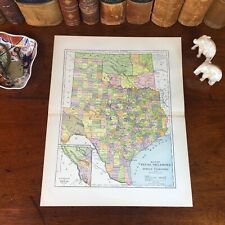
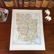
Original 134-year-old Antique Map of North and South Carolina Drawn & Engraved by E.F. Fisk for the 1890 Edition of The People's Cyclopedia of Universal Knowledge: A Compendium of Invaluable Reference in all Departments of the Arts and Life; Illustrated with More than Five Thousand Engravings and Over One Hundred Color Maps of Each State, Principal City, and Territory of the United States, Continents, and Countries Across the Globe. Intricate Detail of County Boundaries, Cities, Towns, Railroads, along with Rivers, Lakes, and other Natural Landmarks. Fine Map for the Collector or Historian. Great for American History and Family Genealogy. Makes an Imaginative and Creative Gift. Easily Framed. Original 1890 Antique Map Drawn and Engraved by E.F. Fisk for the 1890 Edition of The People’s Cyclopedia of Universal Knowledge: A Compendium of Invaluable Reference in all Departments of the Arts and Life, the Whole Brought down to the year 1890, with Pronunciation and Orthography Conformed with Webster’s Unabridged International Dictionary. Illustrated with over Three-Thousand Five-Hundred Engravings and Three-Hundred Color Charts and Maps including each American State, major Cities, including all Territories and United States Possessions, along with a Cadre of World in Hemisphere, Continents, and Nearly Every Sovereign Dominion Across the Earth, Delineating Every Portion of the Known World, the Work Thus Including a Complete and Indexed Atlas of the Globe. NOT A REPRODUCTION. Edited by W.H. DePuy, A.M., D.D., L.L.D. and Henry Frederic Reddall, Assisted by an Editorial Staff including Henry Martyn Paul, Astronomer, U.S. Naval Observatory; Dudley Buck, Composer and Musician; John Clark Ridpath, Author of Ridpath’s Histories, et. al.; and Over One Hundred Special Contributors. Published 1890 by Hunt & Eaton, New York and San Francisco; 1890; a Copy of the Title Page of which is Included. United States 1880 Census Population of Each County listed on Reverse of Map. Dimensions:10.5"x13.5" Map is inExcellent/Very Goodcondition. No writings, marks, or tears. Mild foxing. Single fold as Issued. A Few of the Cities, Towns, Counties, Railroads, and Landmarks Shown on the Map Include:TEXAS:Austin, Dallas, Houston, Galveston, San Antonio, Ft. Worth, Waco, Laredo, Denison, El Paso, Paris, Sherman, Marshall, Tyler, Gainesville, Corsicana, Brownsville, Palestine, Brenham, Corpus Christi, Greenville, Temple, Cuero, Weatherford, Bonham, Beaumont, Cleburne, Abilene, Orange, Wacahachie, Jefferson, Victoria, Sulphur Springs, Belton, Navosta, Bryan, Terrell, Vernon, Texarkana, Eagle Pass, Calvert, San Angelo, Taylor, Denton, Hillsboro, McKinney, Oak Cliff, Georgetown, Anderson County, Jefferson County, Jeff Davis County, Goliad County, Glascock County, Harris County, Hidalgo County, Hutchinson County, Hays County, Irion County, Jackson County, Deaf Smith County, Grimes County, Hunt County, Kerr County, Lampasas, San Marcos, Columbus, Brownwood, Ennis, Henrietta, Marlin, Longview, Dublin, Wichita Falls, Del Rio, Rio Grande City, San Diego, Honey Grove, Luling, Atlanta, Decatur, Yoakum, Seguin, Mexia, Hempstead, Gonzalez, Bastrop, La Grange, Camero, New Braumfels, Clarksville, Colorado, Fort Davis, Ysleta, Hearne, Henderson, Alvarado, Fredericksburg, Huntsville, Rockdale, Bowie, Brockett, Weimar, Round Rock, San Elizario, Ballinger, Rusk, Gatesville, Mineola, Beeville, Flatonia, Kaufman, Uvalde, Caldwell, Wharton, Lockhart, Comanche, Giddings, Pittsburg, Whitesboro, Granbury, Pilot Point, Mason, Nacogdoches, Seymour, Groveton, Aransas Pass, Rockport, Cisco, Kerrville, Meridian, Athens, Wills Point, Ozona, Auld, Ellis, and many others.INDIAN TERRITORY / OKLAHOMA:Portland, Latham, Oakland, Oregon City, Molalla, Yuma, The Dalles, Columbus, Willow Forks, Bridge Creek, Warm Springs, Blue Mountain, Pendleton, Milton, Hawthorne, Helix, Cross Hollows, Bake Oven, Starkey, Mitchell, Parsley, Whitehall, Camp Warner, Lakeview, Tule Lake, Juniper, Christmas Lake, Diamond, Eugene, La Fayette, Aurora, Salem, Milwaukee, Clackamas, Sandy, New Era, Fox Valley, Jefferson, Jordan, Marion, Monmouth, Airlie, Summit, Toledo, Philomath, Corvallis, Tillamook, Silver Lake, and many others. Imaginative & Creative Gift.
Some, to beautify their parlors, chambers, and studies . . . loveth, getteth, and useth, maps, charts, and geographical globes.
-John Dee, Advisor to Elizabeth I.